
All Français articles
Resorts & Destinations
Pourquoi le Japon reçoit-il autant de neige ? Exploration des causes des fortes chutes de neige au Japon
GetSki TeamPublished December 5, 2025· Updated July 17, 2026 7 min read Français

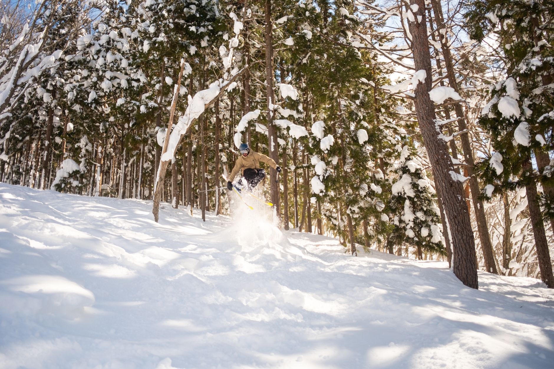
Direct answer: cold air moves from Siberia and meets moist air from the Sea of Japan, and when it is forced up by Japan's mountain ranges, it dumps heavy snow along the coast and in inland belts. Hokuriku and Tohoku routinely record snowfalls around 300–500 cm per year, while Niseko and other Hokkaido resorts can reach 10–16 meters in a season. Sapporo averages about 6 meters annually, and some years push totals higher.
Two forces drive the pattern: the continental cold air that moves in and the moisture flux from the Sea of Japan. Between these bodies of air, mountains force lift, creating persistent snow belts that dominate winter in the Hokuriku corridor and the Japan Alps. The year-to-year pattern depends on the strength of the Siberian High and on sea-surface temperatures, which steer storm tracks across prefectures.
Topography matters most. The long, rugged mountain arc along the Sea of Japan side catches most of the moisture, while the Pacific side stays drier except during big storms. Municipal work and materials for snow control–plows, salt, and grooming gear–have grown with the growth of resorts and a thriving snowboarding scene, allowing towns to stay open and roads to stay passable during peak snow months.
Observatories across countries form a united, worldwide network, sharing data to explain the causes of heavy snowfall in Japan and beyond. The director of a leading meteorological center notes that patterns shift, but the core mechanism remains: move moisture from sea to mountain, then let accumulations grow. For travelers or enthusiasts, this means targeting the right belts–Sea of Japan side for powder and the Alps for larger dumps–and planning to move between locations to experience peak conditions.

Prepare a winter safety plan now: map your zone's snow risk, stock essentials, and review roof loads before the first storm. Distribute a one-page guide to them. Share the plan with residents and neighbors so they know what to do in each zone. Keep a simple kit at hand: warm clothing, a flashlight, a battery-powered radio, 2–3 days of water and non-perishable food, and a small toolkit for basic ground clearance.
In Japan, snowfalls cluster along two main zones: the Sea of Japan side and inland high ground. In each place along that coast, residents adjust routines to cope with heavy accumulation during the months from December to February, with wind-driven drifts that cover ground features and reduce visibility. In peak years, totals over 2 meters are not unusual in remote resorts, while urban centers still report hundreds of centimeters. Be ready for snow events and plan around them. What it means: plan for frequent snow events and extended cold spells.
Homes and streets must be designed to handle load and movement. Check roof load, install snow guards, and keep de-icing substances in labeled containers. Use safe, modern salts and sand, and avoid mixing substances that can damage surfaces. For residents, plan to clear sidewalks promptly and keep ground clear of ice. These tasks move from December to February but can start in late fall as ground freezes. During heavy events, prefer designated walking routes and avoid side streets with wind tunnels.
Suwa features a notable example of tradition meeting winter planning: snow sculpture and local culture turn snowy streets into inviting spaces. In suwa and other towns, winter events turn the season into a chance to celebrate with art and community. When the cold snaps arrive, residents coordinate with local authorities to keep sidewalks safe and accessible. Summer planning helps: name your emergency contacts, review your plan, and align with neighborhood associations.
Tips for daily life: study the forecast zones and wind patterns to see where roads may be closed or ground drift will pile up. If you commute, set a backup plan and call ahead to arrange rides or carpooling. Stock non-perishable foods and warm layers, since events may stall transit for a day or two. For travelers, learn the best place to rent snow tires and equipment, and identify safe parking zones away from drifting snow. These steps help you stay comfortable and safe through the season. Also save emergency calling numbers and share them with family.
Set up two simple alerts to forecast heavy snow: when Pacific moisture rises and temperatures fall, expect peak snowfall in the next 24–48 hours, and alert residents throughout the prefecture to adjust travel plans.
Moisture arrives from two main streams. Among them, moist Pacific air carries humidity toward western Honshu, while cold air outbreaks spill over the Sea of Japan and lift clouds as they clash with mountains. In january, wind contrasts intensify these exchanges, and higher humidity aloft reflect higher snowfall potential near the coast and inland. Many stations report the same signals across valleys, so reading a combined forecast helps refine local decisions.
Cold air outbreaks move from Siberia toward Honshu, and as they meet moist inflows near the Sea of Japan, air is forced upward by mountains, increasing snowfall. Each season, the interaction depends on wind direction–when north or northwest winds prevail, higher snowfall totals appear in the skiing corridors around the prefecture. Move beyond generalities to track daily shifts, because they can differ among coastal and inland areas.
In furukawa, residents feel how gusts sharpen and temperatures plunge during these outbreaks. The director of a regional weather center notes that the january peak aligns with higher snowfall totals in this industrial prefecture. The interaction feels almost magical when moisture and cold air converge in the lee of the mountains, and residents prepare for them–stocking fuels, shovels, and warm wear in advance.
Turn insight into actions with these steps: check the reading from your nearest station every morning, compare it with the broader forecast, and move planning to the next 24 hours. For skiing routes, monitor wind shifts and surface temperatures, since higher winds increase drift and reduce visibility. In the prefecture, communities can share alerts throughout local networks; industrial zones should coordinate with emergency services to keep roads passable. Collect data across many sites, because each valley records different signals, and the more data you gather, the better your move will be. Anything unusual should trigger extra caution and a backup plan.
To prepare for heavy snowfall along the northern coast, monitor forecasts that track moisture being drawn from the Sea of Japan. This approach helps planners and travelers anticipate spikes in snowfall in january and beyond.
The Sea of Japan acts as a vast vapor pump. Warm surface waters feed moist air that moves toward colder land. As this air rises over coastal mountains, vapor condenses into dense clouds and crystal flakes. Fujiko’s experiments with buoy data show that even small increases in sea surface temperatures can lift vapor flux by up to 20%, intensifying snow bands along the coast.
Snow depth grows where colder inland air meets relatively warmer sea air. The temperature contrast exaggerates snowfall rates near the coast, while inland valleys see the air cool quickly, leading to heavy accumulations that can exceed 1–2 meters in extreme winters. This formed pattern underpins the iconic winter landscape of the northern coast.
Snow belts form along the northern coast of Honshu and on Hokkaido, with cities such as Aomori, Akita, and Niigata experiencing frequent heavy dumps in january. The interaction of wind from the Sea of Japan and the mountainous terrain yields persistent snowfall days, often creating a snowpack that lasts through February.
Forecasts that track sea-state, wind direction, and snow-to-liquid ratios help in planning. On days when SSTs are higher and the vapor flux surges, plan for rapid accumulation. For travelers, keep a plan B for rail service disruptions; for logistics, adjust routes to avoid the coast after heavy forecasts. Temperatures along the coast stay milder than inland, yet gusts can drive whiteouts. In january, forecast models indicate the strongest coast snowfall episodes.
Worldwide, scientists compare coastal snow events. Researchers from related fields have found that the Sea of Japan snow belt is sensitive to small changes in air and sea temperatures. Fujiko’s team notes that accessible data streams–forecast models, surface observations, and remote sensing–improve predictive accuracy for 24–48 hours ahead, which helps planning for towns and countries relying on coastal snow forecasts.
Coast communities cu
Envoyez une demande et nous vous ferons une offre personnalisée pour vos dates. Une seule fenêtre au lieu de dix onglets : matériel, transfert et voiture réservés et confirmés à l'avance.