Blog
Ski Travel

Direct answer: cold air moves from Siberia and meets moist air from the Sea of Japan, and when it is forced up by Japan's mountain ranges, it dumps heavy snow along the coast and in inland belts. Hokuriku and Tohoku routinely record snowfalls around 300–500 cm per year, while Niseko and other Hokkaido resorts can reach 10–16 meters in a season. Sapporo averages about 6 meters annually, and some years push totals higher.
Two forces drive the pattern: the continental cold air that moves in and the moisture flux from the Sea of Japan. Between these bodies of air, mountains force lift, creating persistent snow belts that dominate winter in the Hokuriku corridor and the Japan Alps. The year-to-year pattern depends on the strength of the Siberian High and on sea-surface temperatures, which steer storm tracks across prefectures.
Topography matters most. The long, rugged mountain arc along the Sea of Japan side catches most of the moisture, while the Pacific side stays drier except during big storms. Municipal work and materials for snow control–plows, salt, and grooming gear–have grown with the growth of resorts and a thriving snowboarding scene, allowing towns to stay open and roads to stay passable during peak snow months.
Observatories across countries form a united, worldwide network, sharing data to explain the causes of heavy snowfall in Japan and beyond. The director of a leading meteorological center notes that patterns shift, but the core mechanism remains: move moisture from sea to mountain, then let accumulations grow. For travelers or enthusiasts, this means targeting the right belts–Sea of Japan side for powder and the Alps for larger dumps–and planning to move between locations to experience peak conditions.

Prepare a winter safety plan now: map your zone's snow risk, stock essentials, and review roof loads before the first storm. Distribute a one-page guide to them. Share the plan with residents and neighbors so they know what to do in each zone. Keep a simple kit at hand: warm clothing, a flashlight, a battery-powered radio, 2–3 days of water and non-perishable food, and a small toolkit for basic ground clearance.
In Japan, snowfalls cluster along two main zones: the Sea of Japan side and inland high ground. In each place along that coast, residents adjust routines to cope with heavy accumulation during the months from December to February, with wind-driven drifts that cover ground features and reduce visibility. In peak years, totals over 2 meters are not unusual in remote resorts, while urban centers still report hundreds of centimeters. Be ready for snow events and plan around them. What it means: plan for frequent snow events and extended cold spells.
Homes and streets must be designed to handle load and movement. Check roof load, install snow guards, and keep de-icing substances in labeled containers. Use safe, modern salts and sand, and avoid mixing substances that can damage surfaces. For residents, plan to clear sidewalks promptly and keep ground clear of ice. These tasks move from December to February but can start in late fall as ground freezes. During heavy events, prefer designated walking routes and avoid side streets with wind tunnels.
Suwa features a notable example of tradition meeting winter planning: snow sculpture and local culture turn snowy streets into inviting spaces. In suwa and other towns, winter events turn the season into a chance to celebrate with art and community. When the cold snaps arrive, residents coordinate with local authorities to keep sidewalks safe and accessible. Summer planning helps: name your emergency contacts, review your plan, and align with neighborhood associations.
Tips for daily life: study the forecast zones and wind patterns to see where roads may be closed or ground drift will pile up. If you commute, set a backup plan and call ahead to arrange rides or carpooling. Stock non-perishable foods and warm layers, since events may stall transit for a day or two. For travelers, learn the best place to rent snow tires and equipment, and identify safe parking zones away from drifting snow. These steps help you stay comfortable and safe through the season. Also save emergency calling numbers and share them with family.
Set up two simple alerts to forecast heavy snow: when Pacific moisture rises and temperatures fall, expect peak snowfall in the next 24–48 hours, and alert residents throughout the prefecture to adjust travel plans.
Moisture arrives from two main streams. Among them, moist Pacific air carries humidity toward western Honshu, while cold air outbreaks spill over the Sea of Japan and lift clouds as they clash with mountains. In january, wind contrasts intensify these exchanges, and higher humidity aloft reflect higher snowfall potential near the coast and inland. Many stations report the same signals across valleys, so reading a combined forecast helps refine local decisions.
Cold air outbreaks move from Siberia toward Honshu, and as they meet moist inflows near the Sea of Japan, air is forced upward by mountains, increasing snowfall. Each season, the interaction depends on wind direction–when north or northwest winds prevail, higher snowfall totals appear in the skiing corridors around the prefecture. Move beyond generalities to track daily shifts, because they can differ among coastal and inland areas.
In furukawa, residents feel how gusts sharpen and temperatures plunge during these outbreaks. The director of a regional weather center notes that the january peak aligns with higher snowfall totals in this industrial prefecture. The interaction feels almost magical when moisture and cold air converge in the lee of the mountains, and residents prepare for them–stocking fuels, shovels, and warm wear in advance.
Turn insight into actions with these steps: check the reading from your nearest station every morning, compare it with the broader forecast, and move planning to the next 24 hours. For skiing routes, monitor wind shifts and surface temperatures, since higher winds increase drift and reduce visibility. In the prefecture, communities can share alerts throughout local networks; industrial zones should coordinate with emergency services to keep roads passable. Collect data across many sites, because each valley records different signals, and the more data you gather, the better your move will be. Anything unusual should trigger extra caution and a backup plan.
To prepare for heavy snowfall along the northern coast, monitor forecasts that track moisture being drawn from the Sea of Japan. This approach helps planners and travelers anticipate spikes in snowfall in january and beyond.
The Sea of Japan acts as a vast vapor pump. Warm surface waters feed moist air that moves toward colder land. As this air rises over coastal mountains, vapor condenses into dense clouds and crystal flakes. Fujiko’s experiments with buoy data show that even small increases in sea surface temperatures can lift vapor flux by up to 20%, intensifying snow bands along the coast.
Snow depth grows where colder inland air meets relatively warmer sea air. The temperature contrast exaggerates snowfall rates near the coast, while inland valleys see the air cool quickly, leading to heavy accumulations that can exceed 1–2 meters in extreme winters. This formed pattern underpins the iconic winter landscape of the northern coast.
Snow belts form along the northern coast of Honshu and on Hokkaido, with cities such as Aomori, Akita, and Niigata experiencing frequent heavy dumps in january. The interaction of wind from the Sea of Japan and the mountainous terrain yields persistent snowfall days, often creating a snowpack that lasts through February.
Forecasts that track sea-state, wind direction, and snow-to-liquid ratios help in planning. On days when SSTs are higher and the vapor flux surges, plan for rapid accumulation. For travelers, keep a plan B for rail service disruptions; for logistics, adjust routes to avoid the coast after heavy forecasts. Temperatures along the coast stay milder than inland, yet gusts can drive whiteouts. In january, forecast models indicate the strongest coast snowfall episodes.
Worldwide, scientists compare coastal snow events. Researchers from related fields have found that the Sea of Japan snow belt is sensitive to small changes in air and sea temperatures. Fujiko’s team notes that accessible data streams–forecast models, surface observations, and remote sensing–improve predictive accuracy for 24–48 hours ahead, which helps planning for towns and countries relying on coastal snow forecasts.
Coast communities cultivate a culture of preparedness: early planning for snow removal, lantern-lit winter town squares, and crystal-clear decision points for schools and services in january. The snow and cold shape local lifeways and infrastructure, including access to markets and safety planning for winter storms.
Plan your itinerary along the mountain barriers that birth Japan's regional snow belts: target west-facing ranges along the Sea of Japan during the peak months of winter, when cold air from the continent meets moist coastal air. This focus helps you predict where snowfall will accumulate and reduces exposure to rapid melts on inland routes.
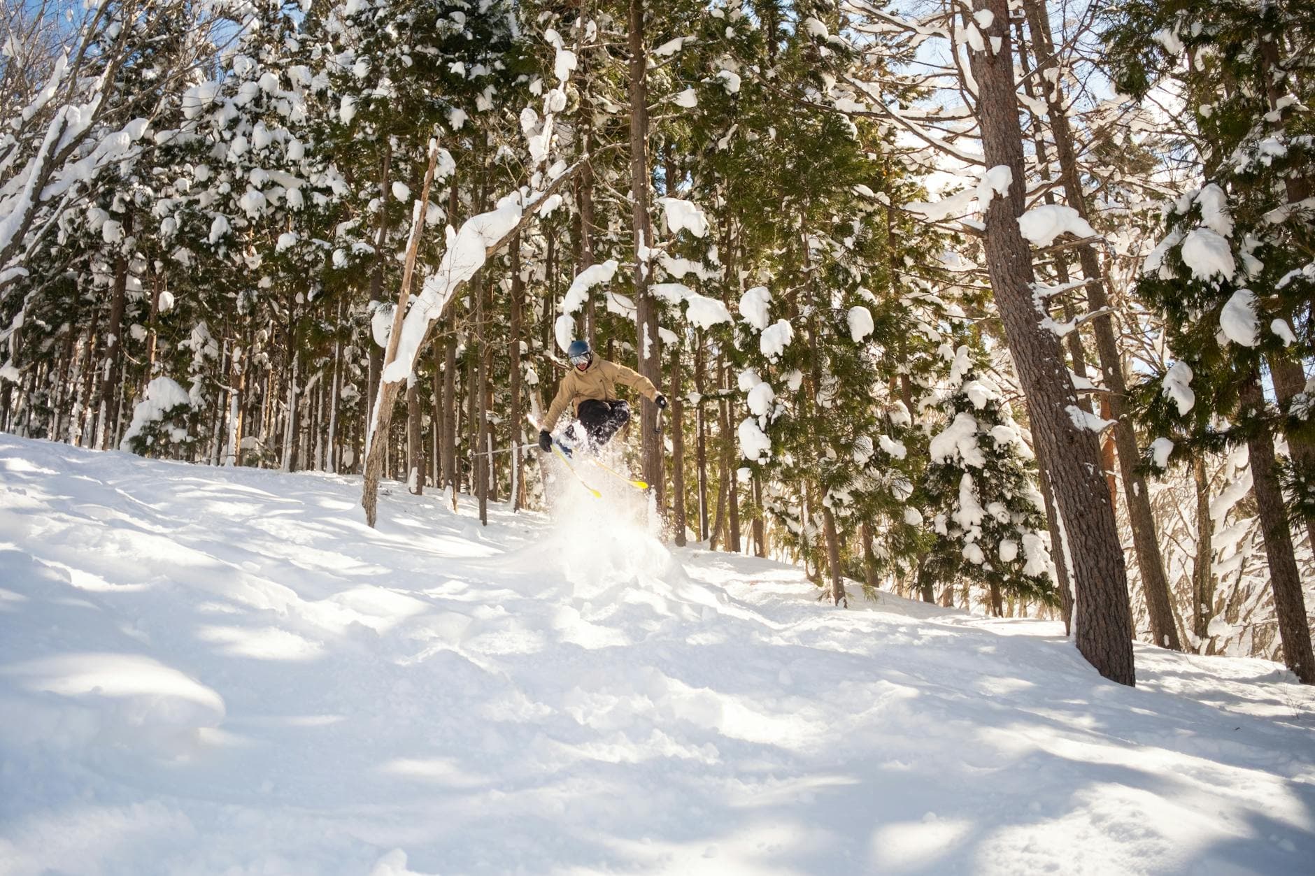
Orographic lift over tall ridges creates a reliable zone of heavy snow. On japans west-facing slopes, snow can pile up quickly, forming multi-meter depths in peak events, while interior fields stay lighter. The barrier effect concentrates moisture and accelerates snowfalls in Hokuriku, Niigata, and other coastal corridors, creating reliable patterns for planning both travel and winter activities.
In cold snaps, phenomena such as omiwatari on rivers signal persistent subfreezing conditions, and this calm persists across many days. For travelers, these signs translate into predictable windows for winter sports, with the best conditions often reported in February and March. Local festival calendars, from north to west, provide cultural anchors for weeks with heavy snowfall, giving travelers a chance to combine slopes with seasonal events.
The snowpack's longevity hinges on temperatures and sun exposure. Cold nights let snow on fields and roofs harden while daytime sun gradually melts weaker layers. Dust, ash, and other airborne substances influence crust formation, which can either slow or speed up melts when temperatures rise. Monitoring crust types helps skiers and resort staff predict spring runoff and maintain safe slopes.
Researchers yoshinori and furukawa quantify how cold-air powers from the continent collide with moisture from the Sea of Japan, locking in heavy snowfall in the zone behind ridges. Their findings explain why the west-facing belts keep snow longer and provide a data-backed basis for tourism strategies aimed at travelers and sports enthusiasts.
For visitors, focus on months with consistent snow and reliable access–February through early March offer solid conditions and manageable crowds. In summer, the same mountain barriers shape storm tracks and shade, guiding hikers and festival planners. Before visiting a mountain belt, check local forecasts, listen for alerts from ski areas, and consider staying in towns that host regional winter events. This approach keeps attention on safety while maximizing enjoyment of the special alpine character.
Start with a practical assessment: classify snow by grain type and density to predict accumulation. Field experiments show density governs how quickly snow settles and how it compacts under wind and traffic. Track two or three samples per storm and log temperature, wind, and timing since snowfall.
In northern areas of Japan, powdery snow dominates during very cold spells, while milder periods yield heavier flakes and crusts. Areas along the Sea of Japan coast often build wind slabs that turn drifts into dangerous banks, especially on slopes facing prevailing winds. Islands and lakes influence microclimates, creating crusts that melt and refreeze, then re-crystalize. A photo log helps document these shifts and makes it easier to compare events from one season to the next.
Density and moisture content shape accumulation patterns. Fresh powder can be as light as 10–40 kg/m3, while wind-packed or wet snow quickly rises to 40–100 kg/m3 or higher. In wet spells, densities of 150–250 kg/m3 are not unusual, and these heavier layers fall more slowly than lighter layers. The prime rule is: heavier is not always earlier; the rate depends on temperature and sun exposure. March storms can deliver consolidation that makes a drift significantly thicker than a single snowfall would suggest.
On the ground, accumulation follows predictable routes: northern areas often see deeper drifts, whereas coastal zones see fluctuations tied to storm tracks from the Pacific and Siberian air. Throughout the season, cycles of fresh falls, wind redistribution, and melt-freeze cycles create layered structures. The question of where does the magical space begin? It begins at the moment crystals form and wind transports moisture from seas and lakes, shaping the first dense layers that will guide later accumulation. These patterns are driven by the causes of moisture transport and temperature contrasts, and are especially visible in islands and lakeside towns, where microclimates produce distinct patterns and news reports often highlight surprising shifts.
Materials you can use for quick field tests include a small kitchen scale, a clear plastic bottle to collect a 10 cm core, a ruler, and a camera for a photo record. Take samples from several spots with different exposure, then weigh and measure to compute density (kg/m3) and estimate snow water equivalent (SWE). Do this throughout a storm and compare results in March storms with the same wind pattern; these experiments turn raw snow observations into actionable data. To travel safely, wear snowshoes when trails are deep or wind‑slab formation is likely.
Where to begin reading the forecast and news? Track local weather services and regional reports for updates on incoming fronts that bring heavy falls. If you are in islands or lakeside towns, monitor lake-effect patterns and follow the latest from researchers, including experiments involving wind and moisture transfer from lakes and seas. From your measurement log, you can forecast more accurately how much will accumulate and how quickly it will turn into ice during March thaws.
Pre-treat and pre-stage snow removal in high-traffic corridors before storms hit, arranging priority to arterials and transit routes so around 60–70% of core services stay operational within a few hours of onset. These tasks are arranged into three tiers: primary arterials, secondary collectors, and local streets, with crews, plows, and brine trucks allocated to each tier. This approach keeps hospitals, fire stations, and train stations accessible, while reducing gridlock for daily commuters.
Coordinate snow removal with transportation planning by aligning plow routes with bus timetables and rail clearance windows; reserve lanes and extend green times on major lines when snow abates. In hokkaido and along the coast, guide drift-prone zones with temporary barriers and snow fences; stage equipment near depots so crews can react within minutes. These coordinated steps help skiers and residents move between destinations during peak weeks and off-peak days alike, and youve got a clearer signal of service restoration for everyone.
Urban design choices ease ongoing management. Store collected snow in designated piles on non-essential lots or at the edge of parks; use snow farms near transit yards to keep sidewalks clear. In furukawa and suwa, planners stage storage in places where they won’t block storefronts or emergency routes, ensuring that each neighborhood remains walkable. They coordinate with local museum districts and classic routes to keep access open, which helps people reach shops, schools, and other places in winter.
Data-driven operations keep the plan responsive. Track wind-driven drift and crystal depth at key corridors and sidewalks, and set triggers whether an extra crew is needed. Use a balanced diet of de-icers–brine ahead of storms, salt for heavy accumulations, and environmentally friendly alternatives in crowded areas–and monitor impacts on pavements and metal. Name a few action points: expand snow-clearing hours after storms, rotate crews to prevent fatigue, and run drills in a coordinated fashion across regions, so these efforts come together when heavy snow arrives in hokkaido or suwa, not just during mild winters. If youve to ensure consistency, use cross-agency dashboards that compare coast and inland regions, and you can see how cause of heavy snowfall shapes readiness.